Wednesday, October 22, 2008

Looping Brownsville

Brownsville is about to see a new decade filled with ever expanding retail, hotels, restaurants, medical facilities such as expanding hospitals and clinics, international trade, growing port and air port, schools, explosive growth of UTB/TSC and the ever so elusive renaming of HW 77/83 to I-69. But most of these growths and expansions will not happen without a complete, or at the very least partially complete loop around Brownsville to help keep traffic moving and developing land that at this time remains empty. The loops that will help launch Brownsville into the stratosphere are called the West Loop and East Loop.

These two loops have already come before the public prior to construction. Both have been proposed as tolled, limited access highways such as the Expressway 77/83. Though I, for one, have opposed the tolled part of the projects at public meetings and in writing to CCRMA (Cameron County Regional Mobility Authority), who is responsible for the two loop projects, there is no doubt that these loops are needed in order for Brownsville to grow in a positive manner. Just look at the economic benefits that the HW 77/83 has provided for Brownsville. There is no question that without the expressway, as it is commonly referred to, has had an irreversible positive effect on the city of Brownsville. Without the expressway, there would not have been a Sunrise Mall or all of its numerous shopping centers, The Valley Regional Medical Center and the Doctor’s Hospital would not have been built, all the hotels along the expressway would be vacant lots, and absolutely everything that is there now would more than likely not have been there. Where would Brownsville be without the expressway? It would be a little town that had no major connection to the rest of the valley much less connected to the rest of the state and nation. The old Highway 77 was a pothole filled, two-lane highway that would never have been able to handle the traffic that exists today. Even the expressway had to be recently expanded to three lanes just to accommodate the traffic we have today and will likely have to be expanded again in the next 20 years (it took forty years before it was expanded due to the explosive growth here) if current projects shows Brownsville at over 350,000+ by 2030. Let’s look now at each of the loops being considered for construction in the near future and what they will do for the area that it will be built on.


East Loop


As currently envisioned, East Loop will stretch from the intersection of International Blvd and Elizabeth St. to the expressway (this segment has been built but as a four-lane boulevard named University Blvd) from the expressway to the airport via the outer most part of Southmost along the levee of the Rio Grande River and loop into the airport, from the airport to the Port of Brownsville and from the port to back to the expressway north of Brownsville along the existing FM 511 (this portion is under construction as the frontage roads are being built until the highway funding can be found).


What does this new loop mean for Brownsville? Everything. Trucks would have faster routes around the city and easy access to the airport, the Port of Brownsville, the Veteran’s Int’l Bridge and UTB/TSC and the Gateway Int’l Bridge. It would be, in effect, a semi-loop on the east side of Brownsville from the intersection of FM 511 and the Expressway 77/83 to the Veteran’s International Bridge on the south side of the city. Trucks and large rigs would be able to use this portion of the highway and reduce burden on the expressway within the center part of the city. This means safer travel for everyone else using the expressway. Just think how easy it would be to get to the airport without leaving the expressway? This is one of the many benefits of East Loop. Also, this new connection would help Southmost as a new highway that winds around this area would bring new businesses that would otherwise overlook due to poor access to this side of the community. Land around the port and FM 511 to the expressway would also enjoy new construction of residential and businesses.


West Loop


This is another project that the City of Brownsville and Cameron County have been dreaming about since the announcement of the removal of the rail line that starts at the B&M Int’l Bridge and goes to north Brownsville. A new international rail bridge will be built in the near future (5 to 15 years from now) and the tracks that will be left behind will revert to the city of Brownsville. The city will have 100 feet of right-away on each side of the track and the length of the loop will be about eight miles long.


This loop, as I envision, will help downtown Brownsville due to its proximity. The downtown business center would only be a few blocks away rather than about ten blocks from the current expressway. For a downtown to survive, it needs immediate access to a major highway. Otherwise, most people will avoid going to downtown if access is not immediate. In today’s world, people want to get to place ASAP and not deal with the hassle of driving long distances.
Also, since the West Loop will connect with the B&M Int’l Bridge, Brownsville will have two direct accesses to two international bridges. The West Loop will travel parallel to the existing highway and will provide needed relief on the current expressway. A whole new avenue of opportunity waits with the construction of West Loop and its exciting future for downtown.
Another reason for the construction of the West Loop is the attraction for developers in building the greatest project to come to downtown ever. This is the proposed project called Brownsville Crossings. This project envisions a shopping center nearly the size of the Sunrise Mall and includes a river walk between the Gateway Int’l Bridge and the B&M Int’l Bridge. Along the river walk will be retail and restaurants similar to the San Antonio River Walk. Of course, all this is pending not just on the West Loop but also on DHS’s planned border wall. If an agreement can be reached between the city, the developers, and DHS on the planned river walk and the border wall, then bringing the West Loop in would also have a positive spin being that the proposed shopping center would be a mere ¾ mile from West Loop via 12th Street (Sam Pearl Blvd). With a direct access to a major highway, this project would be a hit for tourists and locals alike.


The Future of Brownsville


Brownsville is in a midst of an ever growing population and size and it only stands to reason that with added growth come added strains and stresses of everyday life such as driving from one side of the city to the other. The more congested our streets get, the more difficult and longer it takes to get from point A to point B. Not only will it take longer to travel within Brownsville but pollution will also be a major concern in the near future. With more cars on our streets idling at traffic lights, the more probable that Brownsville will begin to see smog forming over our city and blanketing the sky for long periods of time.


Currently, the expressway is the only means of traveling in the city unencumbered and with the recent expansion of the expressway to three lanes, it will only take twenty years before the highway will have to add a fourth lane just to keep up with congested and keep the highway from coming to a halt on peak hours. Then, it would only take ten more years to have to add a fifth lane and so on. If Brownsville doesn’t any other means by which traffic can move unimpeded, then Brownsville will hit a wall and growth will slow down and congestion will be a daily complaint. What’s needed is a way to keep Brownsville moving not just today but tomorrow as well. Our city has one of the youngest populations in the nation and each and every one of these people will need cars as our city grows. How will the population of the future deal with congestion? By adding a loop around Brownsville and connecting different areas of our city that today is not easily done.


Looping Brownsville is the answer to our city’s growth and its ability to continue growing without screeching to a halt. Both the West Loop and East Loop proposes to do this and our future depend on it. Forty years from now, we will see the fruits of this labor, which could take decades to fully complete, and wonder how Brownsville could have survived without this loop. Just think about that when you are travelling on Highway 77/83 next time.

Tuesday, October 07, 2008

Boundary Adjustment Feasibility Study for Fort Texas


Boundary Adjustment Feasibility Study for the Original Fort Brown Earthworks

PRESENTED TO: University of Texas at Brownsville and Texas Southmost College

SUBMITTED BY: Mary Kralovec, Superintendent Palo Alto Battlefield National Historic Site


I. INTRODUCTION

Background:

In June, 2008, a Fort Brown Preservation working group was established to identify the feasibility of adjusting the Palo Alto Battlefield National Historic Site administrative boundary to include the Original Fort Brown Earthworks. Representatives from the University of Texas at Brownsville and Texas Southmost College (UTB-TSC), Brownsville Historic Association, Cameron County Historical Commission, City of Brownsville, Historic Brownsville Museum, Palo Alto National Park Committee, and Palo Alto Battlefield National Historic (PAAL) site were represented in the working group.

At a July 2008 work group meeting, the PAAL Superintendent was asked to provide a geographic boundary for the Original Fort Brown Earthworks. A National Park Service project team; consisting of the park superintendent, historian, and archeologist; developed a map with the recommended preservation boundaries. The proposed boundary included the standing ruins of the earthworks, as well as the entire foot print of the structure where there is still a potential to have intact subsurface features associated with the fortification. This information was shared with the Fort Brown Preservation working group in August, 2008.

As a follow up to the recommended boundary adjustment, the PAAL Superintendent was asked in early September 2008 to provide a feasibility analysis of the boundary adjustment proposal. This report reflects an analysis of alternatives associated with changing the PAAL administrative boundary to include the Original Fort Brown Earthworks.

II. HISTORY

Fort Brown-Earthen Fort:

General Zachary Taylor ordered construction of the original Fort Brown (often referred to as Fort Texas) in March 1846. He desired a substantial system of earthworks to provide protection for his “Army of Occupation” which had been sent to claim the Rio Grande as the southern boundary of the United States. He requested that the post be large enough to harbor at least one of the three brigades of his 4000-man army, in the likely event that it came under fire from Mexican troops that opposed his advance.

Responsibility for design and construction of the post fell upon engineer Captain J. F. K. Mansfield. Mansfield mapped out an ambitious six-sided earthwork, with bastions at each corner. The star-shaped structure had sloped walls 9 feet high, with additional parapets at the top which raised the profile to 15-feet in height. The length of the walls ranged from 120-150 feet. Additional shelters and bomb-proofs were constructed in the interior of the fort. Around the exterior, he planned for the creation of a moat, 10-15 feet deep and up to 20 feet wide.

Construction commenced on the earthwork in late March and soldier work crews toiled from dawn to dusk throughout the month of April. The fort was largely complete when Mexican forces crossed the Rio Grande on April 24 and attacked a U.S. scout party the following day. Taylor’s troops then worked around the clock on the site until May 1 to ensure that the post could withstand an assault. The U.S. General then placed the fort in the hands of Major Jacob Brown and a force of 500 men, before marching his army to Point Isabel to gather the supplies and materiel required to hold off a possible siege of Fort Texas.

The lightly-manned fort soon became the center of conflict. Mexican forces had intended to trap Taylor in the fort and institute a siege. Difficulties in traversing the Rio Grande, however, delayed this effort. General Mariano Arista pursued Taylor to Point Isabel but failed to overtake him. With the main American force safely ensconced in its coastal depot, Arista ordered a bombardment of Fort Texas as a ploy to draw Taylor into a fight. Firing commenced at daybreak on May 3 and would continue for 6 days.

Arista’s bombardment had its effect. On the evening of May 7, U.S. troops departed the coast and moved to rescue their fort. On May 8, at Palo Alto and May 9 at Resaca de la Palma, U.S. and Mexican forces faced-off in the opening battles of a prolonged war between their nations. U.S. victory in the second battle forced Arista to retreat back across the Rio Grande and ended the siege of the fort. Days later, as Taylor prepared to cross the river and occupy the Mexican city of Matamoros, he ordered the earthworks to be named Fort Brown, in honor of the commander who died during the siege.

The earthwork was abandoned following the occupation of Matamoros, but Fort Brown survived. Following the war with Mexico, activities and construction of fort facilities moved about ¼ to the north. The Fort Brown reservation remained an active outpost until 1945 when it was deactivated by the War Department, almost 100 years after its founding. The fort, including the historic earthworks, is on the National Register of Historic Places and is a National Historic Landmark. Currently, the Fort Brown – Earthen Fort and historic buildings are owned by the International Boundary and Water Commission and maintained and managed by the UTB-TSC.

National Register of Historic Places

The Original Fort Brown Earthworks and Historic Fort Brown were adopted onto the National Register of Historic Places in 1996. The National Register of Historic Places is the official list of cultural resources in need of preservation. Authorized under the National Historic Preservation Act of 1966, the program works to coordinate and support public and private efforts in identifying, evaluating, and protecting historic and archeological resources. Properties listed in the Register include districts, sites, buildings, structures, and objects that are significant in American history, architecture, archeology, and culture.

National Historic Landmark Designation:

National Historic Landmarks (NHL) is nationally significant historic places designated by the Secretary of the Interior because they possess exceptional value or quality in illustrating or interpreting the heritage of the United States.

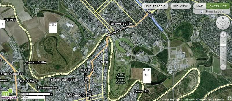
Fort Brown, which includes the Original Fort Brown Earthworks, was designated as a NHL on December 19, 1960 and consists of three discontinuous historic districts. One comprises the standing ruins of the original earth fortification. The second consists of Fort Brown’s remaining historic Calvary Barracks and, the third encompasses a number of historic buildings that date from 1868. The Original Fort Brown Earthworks NHL boundary includes the remaining intact part of the breastworks constructed by General Taylor in 1846. The boundary forms a rectangle measuring 80 yards north/south by 170 yards east/west around the site. Beginning at the intersection of the two levees, the boundary proceeds east-southeast along the top of the levee for a distance of 170 yards (Fig. 1). The boundary then turns south-southwest for a distance of 80 yards and west-northwest for a distance of 170 yards. The last turn is north for 80 yards along the top if the western levee (Fig. 1)

Fig. 1. Outline of Original Fort Brown Earthworks on current aerial photograph of site.


Fort Brown is a nationally significant place due to its prominent role in the U.S. War with Mexico and U.S. Civil War and as a training ground in the Spanish-American War and mobilization point for border defense during the Mexican Revolution era. Throughout its early history, Fort Brown contributed significantly to the growth and defense of U.S. territory.

IV. LAND STATUS

The Original Fort Brown Earthworks has been dramatically altered since its construction in 1846 and little remains of the original earthen walls (Fig. 1). Currently, approximately 230 linear yards of exterior parapet and bastion walls remain standing as ruins, representing less than 25% of the original earthworks (Fig. 2). The original earthworks occupied approximately 12 acres. Of this, approximately 2.5 acres remain intact and undisturbed.

It is unclear why dirt from the earthen walls was removed and where it was transported to after removal. As late as 1939, aerial photographs appear to indicate that the earthwork walls were intact. However, by 1950, much of the earthen walls had been removed from its original location. Dirt from the earthen walls was likely used to construct the modern levee system which is still in use today.

Fig. 2. Existing standing ruins at the Original Fort Brown Earthworks site.


V. NATIONAL PARK SERVCE BOUNDARY ADJUSTMENT RECOMMENDATION

The National Park Service recommendation for inclusion within the Palo Alto Battlefield National Historic Site boundary includes the area contained within the NHL boundary plus lands to the north and east of the intersection where two levees meet (Fig. 3). This entire area has the potential to contain subsurface features; as revealed through ground penetrating radar surveys (Nickel and Nickel: 2004). The boundary was derived from the Mansfield’s 1846 scale drawing of the original earthworks (Fig. 4). The National Park Service recommends preservation of the additional area outside of the NHL boundary to protect the entire fort and preserve any subsurface remains that may still exist.

VI. PUBLIC USE POTENTIAL

As a Tourist Destination:

As a tourist destination, Fort Brown would likely attract visitors from the local, regional, and national arenas. The Fort Brown site is the location of one of the key battles which drew the United States and Mexico into a war over disputed territory. Each of the three battlefield sites (Fort Brown, Resaca de la Palma, and Palo Alto) are strategically located along a north-south gradient and geographically linked along the old Port Isabel to Matamoros road. Together, they help to tell the story of the strategic importance of the southern tip of Texas to the United States and the Rio Grande delta.

Efforts are currently underway to adjust the PAAL boundary to include Resaca de la Palma and to change the name of the park to Palo Alto National Historical Park. Inclusion of the Original Fort Brown Earthworks in the PAAL boundary would complete the story, assure further protection for this valuable historic site, and allow increased interpretation and promotion of the earthworks by the National Park Service. Because this National Historical Park will be nationally recognized as the only NPS unit dedicated to commemorating the U.S. War with Mexico it will likely draw visitors from the local area and around the country to the area. At each of the three sites, visitors would learn about site specific events and why each site is strategically tied to the other. A visitor center, as outlined in the park’s General Management Plan, could be developed on the university campus and used to interpret and draw visitors to Fort Brown.

The site will also likely draw researchers and students from the local, regional, and national arenas to study the sites archeology and history.

Tourism/Visitor Use in Immediate Area:

Brownsville, Texas is the southernmost city in the continental United States that shares a border with Mexico. Brownsville is 25 miles inland from the Gulf of Mexico and is directly across the border from Matamoros, Mexico.

The population in Brownsville is approximately 170,000. Visitors from all over the United States come to the Brownsville area for sunshine, warm climate, excellent ocean beaches, and the opportunity to visit Mexico. Many individuals from Mexico visit the Brownsville for shopping, commerce and tourism, and access to the ocean beaches.

Fig. 3. National Park Service Palo Alto Battlefield National Historic Site boundary adjustment recommendation. The recommended boundary adjustment is represented by the area within the solid green line. Section A, B, and C represented the National Historic Landmark designations.

Fig. 4. Mansfield’s 1846 scale drawing of the Original Fort Brown Earthworks used as a basis for the Palo Alto Battlefield National Historic Site administrative boundary adjustment recommendation.


History is very important to the region’s leaders and residents. The City of Brownsville Convention and Visitors Bureau has recently unveiled a new logo which emphasized the cities historic roots. The logo “Brownsville-With A History As Big As Texas” is designed to emphasize the important role Brownsville has played in our nation’s history.

In 2008, visiting historic sites and parks were among the top 10 leisure activities for tourists when visiting Texas, comprising over 13% of all visitors. It is estimated that states and communities who invest in the development of heritage and cultural tourism offerings are realizing a greater and faster return on their investment than other types of tourism products. According to a recent article in an Austin paper that was written on heritage tourism along the border, “…heritage destinations on the border are attracting more visitors and providing the base for an emerging tourism industry.”

The following population centers exist within a 75-mile radius of the Original Fort Browns Earthworks site. They include:

Brownsville, Texas 170,000
Los Fresnos, Texas 5,400
San Benito, Texas 25,000
Harlingen, Texas 66,000
Port Isabel, Texas 5,000
South Padre Island, Texas 2,700
Matamoros, Mexico 422,000

VII. SITE EVALUATION

The National Register of Historic Places and National Historic Landmark designations have documented and assessed the Original Fort Brown Earthworks as important resource to preserve for the nation.

By nature of its designation on the National Register of Historic Places and as a NHL, the Original Fort Brown Earthworks have been identified by Congress and the American people as a place of historical significance and in need of preservation for future generations to learn from and enjoy.

Local and regional entities support the protection and preservation of Fort Brown, including the original earthworks site.

The long term preservation and protection of the Original Fort Brown Earthworks has strong local and regional support. In 1988, a proposal to preserve and interpret the earthworks was developed by the Brownsville Community Foundation, Palo Alto National Park Committee, and University of Texas at Brownsville and Texas Southmost College. At that time, nine federal, state, city, and non-profit entities supported the proposal.

For this proposal, UTB-TSC staff emphasized the importance of continuing to provide potential educational opportunities, advancing cultural and historical missions, and providing community service through the preservation of the Fort Brown earthworks. State Senator Eddie Lucio, Jr., also emphasized the importance of maintaining the Fort Brown earthworks as an important part of our nation’s history. More recently, a report written by Dr. Antonio Zavaletta and Dr. Gene J. Paull, UTB-TSC (2008) called the original breastworks of Fort Texas, one of our nation’s most significant military sites.

Land contained within the recommended boundary adjustment is owned be several landowners.

Landowners include the University of Texas at Brownsville and Texas Southmost College, International Boundary and Water Commission, Texas National Guard, and Army Reserve. The City of Brownsville leases the property south of the east/west levee from the International Boundary and Water Commission. This land is, in turn, sub-leased by the UTB-TSC for operation of a public golf course and driving range.

The Original Fort Brown Earthworks is very accessible through the UTB-TSC campus.

Located next to the Fort Brown Memorial Golf Course, the earthworks are easily accessible for interpretative, research, management, and maintenance activities. Road access is available from University Drive and parking is available at the Fort Brown Memorial Golf Course.

The original earthworks have been modified over time, but existing natural and cultural resources are currently protected.

The land comprising the original earthworks has changed dramatically from when the fort was constructed in 1846. Less than 25% of the earthwork exists in its original state. In the past 162 years, dirt from the earthwork walls may have been removed to construct and reinforce levees, for fill in building construction, and for various other purposes during the fort’s occupation.

VIII. ALTERNATIVES, BENEFITS, AND COSTS ASSOCIATED WITH MANAGING THE ORIGINAL FORT BROWN EARTHWORKS.

ALTERNATIVE 1

NO ACTION:

Existing conditions would continue. The Original Fort Brown Earthworks would remain in public hands and continue to be managed by UTB-TSC, International Boundary and Water Commission, and City of Brownsville with no other outside agency involvement.

Benefits:

· No change in management strategies and impact to landowners or the local community. All landowners of battlefield tracts would retain title to their property.
· The site would remain on the National Register of Historic Places and NHL lists.
· Congressional authorization would not be needed to adjust the Palo Alto Battlefield National Historic Site boundary to include the site.
· Congressional appropriations would not be needed for the management and operation of the new National Park Service unit.

Costs:

· The site would not be available to the general public for use or enjoyment.
· The site would not receive extra protection and national recognition as a unit under the National Park Service system.
· National Park Service resources, such as staffing and funding, would not be expended at the site for maintaining, interpreting, researching, and managing the site.
· The City of Brownsville and UTB-TSC would not benefit from increased tourism associated with a National Park Service unit in downtown Brownsville.
· The remaining walls will continue to deteriorate with time and limited stabilization. If allowed to continue, the walls will become dispersed; resulting in minimal to zero above ground structure.
· Proposed activities and development on the site as a National Register of Historic Places and NHL would subject to applicable federal and state regulations, including Section 106 of the National Historic Preservation Act and Endangered Species Act.

ALTERNATIVE 2

INCLUSION OF THE ORIGINAL FORT BROWN EARTHWORKS IN THE PALO ALTO NATIONAL HISTORIC SITE BOUNDARY AND MANAGEMENT BY THE NATIONAL PARK SERVICE:

The administrative boundary of Palo Alto Battlefield National Historic Site would be changed to include that area recommended by the National Park Service (Fig. 3). The area would be identified as part of Palo Alto Battlefield National Historic Site and included as a unit within the National Park Service system. The current landowners would continue to maintain title and ownership over all lands contained within the boundary adjustment. However, the site would be co-operatively managed by the National Park Service and UTB-TSC.

A visitor contact station or kiosk, parking area and wayside exhibits would be located near the Unit or somewhere on the UTB-TSC campus. The facilities would be managed by UTB-TSC. The visitor contact station would be staffed and visitor service programs provided by the National Park Service. The visitor contact station and wayside exhibits would tell the story of the military engagements which took place at the Original Fort Brown Earthworks and historic Fort Brown as well as highlight the area’s rich cultural and natural heritage. A Memorandum of Understanding would be developed between UTB-TSC and the National Park Service for co-management, protection, interpretation, and maintenance of the lands designated within the new Unit. The National Park Service would provide natural and cultural resource recommendations and guidance for the site.

Benefits

· All landowners of battlefield tracts would retain title to their property.
· The site would remain on the National Register of Historic Places and NHL lists.
· The site would receive additional protection and national recognition as a part of the National Park Service system.
· A Memorandum of Understanding to co-manage the site between the University and National Park Service would be developed.
· National Park Service resources, such as staffing and funding, would be expended at the site for maintaining, interpreting, researching, and managing the site.
· The City of Brownsville and University would benefit from increased tourism associated with a National Park Service unit in downtown Brownsville.
· The site would be eligible for federal dollars which are earmarked for National Park units.
· The site would be promoted as a unit in the National Park System which would result in increased visitation to the site and University.
· Historic resource and archeological studies and stabilization work would be completed through National Park Service funding.
· The collective resources of one state and federal agency would be used to interpret the history of and protect the cultural resources at the site.
· University staff and students would be actively involved in completing research and interpretation at and assisting National Park Service staff with stabilization of the site.
· Additional federal funding will be available for site stabilization, archeological surveys, historic resource studies, interpretation, and research.

Costs

· Congressional authorization would be needed to adjust the Palo Alto Battlefield National Historic Site boundary to include the site.
· Congressional appropriations would be needed for the management and operation of the new National Park Service unit.
· Activities which adversely affect the enabling legislation and reason for the site’s designation as a National Park unit would be difficult for landowners within the recommended boundary adjustment to complete or conduct. The 1916 Organic Act which established the National Park Service, instructed the service “…to promote and regulate the use of Federal Areas known as national parks, monuments, and reservations…to conserve the scenery and natural and historic objects and the wildlife therein and to provide for the enjoyment of the same in such manner and by such means as will leave them unimpaired for the enjoyment of future generations.”
· Proposed activities and development within the newly established park unit would be subject to applicable federal and state regulations, including Section 106 of the National Historic Preservation Act and Endangered Species Act.
· The designation as a National Park unit will elevate the site to the national level in the eyes of the public and, in return, be subject to additional public input and scrutiny for any proposed activity of development.
· Congressional interest in and oversight of the site will be greater after designation as a National Park.

ALTERNATIVE 3

UTB-TSC AND NPS COOPERATIVELY MANAGE THE ORIGINAL FORT BROWN EARTHWORKS NATURAL AND CULTURAL RESOURCE AND INTERPRETATION ACTIVITIES

The administrative boundary of Palo Alto Battlefield National Historic Site would not be changed to include that area recommended by the National Park Service (Fig. 3).

A visitor contact station or kiosk, parking area and wayside exhibits would be located near the Original Fort Brown Earthworks or somewhere on the UTB-TSC campus. The facilities would be managed by UTB-TSC. The visitor contact station and wayside exhibits would tell the story of the military engagements which took place at the Original Fort Brown Earthworks and historic Fort Brown as well as highlight the area’s rich cultural and natural heritage. A Memorandum of Understanding would be developed between UTB-TSC and the NPS interpretation services at the visitor center. The National Park Service would provide natural and cultural resource recommendations and guidance for the site.

Benefits

· All landowners of battlefield tracts would retain title to their property.
· The site would remain on the National Register of Historic Places and NHL lists.
· A Memorandum of Understanding between the University and National Park Service to provide interpretive services at the visitor center would be developed.
· Congressional authorization would not be needed to adjust the Palo Alto Battlefield National Historic Site boundary to include the site.
· Congressional appropriations would not be needed for the management and operation of the new National Park Service unit.
· The site would be available to the general public for use and enjoyment.

Costs

· The site would not receive extra protection and national recognition as a unit under the National Park Service system.
· National Park Service resources, such as staffing and funding, would be limited and restricted to that agreed upon under a Memorandum of Understanding between UTB-TSC and PAAL.
· The City of Brownsville and UTB-TSC would not benefit from increased tourism associated with a National Park Service unit in downtown Brownsville.
· The remaining walls will continue to deteriorate with time and limited stabilization. If allowed to continue, the walls will become dispersed; resulting in minimal to zero above ground structure.
· Proposed activities and development on the site as a National Register of Historic Places and NHL would be subject to applicable federal and state regulations, including Section 106 of the National Historic Preservation Act and Endangered Species Act.
· Additional federal funding for National Park Service units would not be available for site stabilization, archeological surveys, historic resource studies, interpretation, and research.

IX. References Cited

Nickel, Robert K. and Catherine A. Nickel. 2004. Feasibility Test of Ground-Penetrating
Radar at the First Fort Brown. Prepared for Palo Alto Battlefield National Historic Site,
National Park Service.
Zavaleta, Antonio and Gene J. Paull. 2008. The Original Breastworks at Fort Texas. Prepared
for University of Texas at Brownsville/Texas Southmost College.


Appendix A


IX. STUDY TEAM MEMBERS:

Mary Kralovec
Superintendent
Palo Alto Battlefield National Historic Site

Douglas Murphy
Historian/Chief of Operations
Palo Alto Battlefield National Historic Site

Rolando Garza
Archeologist/Chief of Resource Management
Palo Alto Battlefield National Historic Site

X. FORT BROWN PRESERVATION WORKING GROUP


Name: Organization

Ben Reyna: UTB-TSC
Doug Ferrier UTB-TSC
John Hawthorne: UTB-TSC
Milagro Hernandez: UTB-TSC
Laurie Howell: UTB-TSC
Paul Kavanaugh: UTB-TSC
Tony Knopp UTB-TSC, Brownsville Historical Association
Larry Lof: UTB-TSC, Brownsville Historical Association, Cameron County Historical Commission
Allen Peakes UTB-TSC
David Rivera: UTB-TSC
Dr. Ruth Ragland UTB-TSC
Rene Torres: UTB-TSC
Dr. Antonio Zavaleta UTB-TSC
Joe Gavito: City of Brownsville
Walter Plitt: Plitt Crane & Rigging
Marisela Cortez Historic Brownsville Museum
Javier Garcia: Historic Brownsville Museum
Rolando Garza: Palo Alto Battlefield National Historic Site
Mary Kralovec: Palo Alto Battlefield National Historic Site
Dr. Douglas Murphy: Palo Alto Battlefield National Historic Site

Thursday, September 25, 2008

Imagine Brownsville Imagines a New Look for Downtown and Amigoland

Imagine Brownsville has recently come up with a proposal to revitalize downtown, not that this hasn’t been done before, and the area around the ITEC (former Amigoland Mall area) that looks into developing the river front from the Gateway International Bridge to Palm Blvd. This is an area that has been neglected for so long an is now time to see this area grow but only after we know what DHS is going to do regarding the border fence/wall.

After having read the Imagine Brownsville’s presentation on downtown revitalization, I was pleasantly surprised to see the Amigoland area where the ITEC is located included in the proposal. This presentation can be found at: http://www.imaginebrownsville.com/communitypresentations/Imagine%20Brownsville%20Downtown%20Revitalization%20Strategy%20Presentation.pdf.

The last three pages of this presentation caught my eye the most since the rest of the presentation touches on the core of business district of downtown that has been dissected with a microscope over the decades. The only difference with the downtown presentation is the way the river front would be developed. Going back to the last three pages I was glad to see some “real” effort on developing the Amigoland area. One developer has already plunged his money in this effort with a planned subdivision at the end of Palm Blvd where the 21st Century Rides would locate during Charro Days.

The first phase of the development appears to be nearing completion as streets have already been built and paved near the Rio Grande River. I went by this area a few months ago and there are even street signs posted. So someone sees some future in this area but other than this developer, which has also cleared the once dried up Resaca and replenished it with water, no one else has been willing to risk or even look into the possibility of developing this area other than maybe UTB/TSC.

The proposed project would make the area including the ITEC into a Venice styled waterways creating one large island where the ITEC is and three smaller ones with residential and commercial development. One of these islands is a large park in the middle of the development connected with bridges. This is a fantastic idea and should be given further scrutiny by our city commission as a viable development that a private developer would be interested in doing. This size and scope of a project would be best built after the current economic crisis is over. I, for one will send the commission my tentative approval for such a development if a private developer builds it. Something like this would be a definite draw to downtown.

The rest of the proposal is also fantastic but will take a heavy involvement from the city, county, and private developers to make this happen. But knowing politics around hear, I’ll be happy to see even just a quarter of this proposal built.

After reading this presentation, please contact the city commission and let them know what you feel about this development.

Monday, July 16, 2007

The Great Wall of USA: Why it Will Fail

The Great Wall of China was built, over time starting in the 221th Century BC, as a method of stopping the invading army from the north. With time, the wall had eroded or sections destroyed and rebuilt time and time again until 1644, when the Manchus managed to cross the wall. Since then, they conquered lands far beyond the reach of the Great Wall and slowly the maintenance of the wall was reduced until it was forgotten. Move forward to the 21st Century and many walls around the world had been constructed only to be forgotten because they never fully accomplished their mission; to stop others from entering. Other reasons include changes in politics, high cost of maintenance, areas conquered beyond the wall, or forgotten over time only to be remembered in the history books. Let’s look at why this wall or fence is no different from all the ones before it: cost, politics, maintenance, geography, environmental, man power, and views about what a wall means to Mexicans, to name a few.
According to the International Boundary and Water Commission, the distance between the U.S. and Mexico from the Gulf of Mexico to the Pacific Ocean is 1,951 miles. The Rio Grande River (Rio Bravo in Mexico), which is the dividing line between the U.S. and Mexico, extends for 1,254 miles from the Gulf of Mexico until it reaches El Paso. Like all rivers, the Rio Grande River is not a straight river but a meandering river much like a snake slithering across the ground. Just in one linear mile, a river, if extended to form a straight line, can stretch for tens of miles due to the fact that the river can zigzag much like writing in cursive. Also, there is very thick vegetation that stretches along the river banks for hundreds of miles that is a life sustaining force for all creatures that live and require the river to survive.
If a wall or fence were to be built along the Rio Grande River, just imagine the logistics of building it. Would you follow the actual river, which would mean multiplying the 1254 miles by an average of a winding river if it were to be stretched in linear form, or building the wall (from now on I will refer to the wall as both an actual wall or fence since there is no way of knowing which one will be built) some miles away to form a straight line? This would equal to about 5,000 to 10,000 miles of river! Following the actual river would require about five to ten times as much material (averaging 5 to 10 miles of stretched linear river per mile) to build a wall. If the wall were to be built some miles away from the river to form a straighter wall, that would required eminent domain to “take away” land that has belonged to people who have lived there all their lives and need and require the river to sustain their agriculture and live stock.
Like all rivers, the Rio Grande River does, on occasions, change shape do to flooding, erosion, and even human intervention. This, intern, changes the boundary between the US and Mexico. This can happen when a river changes course by winding back onto itself creating a loop and then cutting off to a new direction leaving a piece of land cut off from one country and entering into another. If, say the wall were to be built along the river banks and a hurricane came along dumping enough rain to cause substantial flooding, which, in turn, causes the river to change shape, thereby changing the international boundaries, then not only will parts of the wall be destroyed but could also end up on the Mexican side. Mexicans would only be so happy to pick at it until nothing was left. Also, the US would be forced to spend more billions of dollars to fix or rebuild the wall and any roads. Nature is a force to be reckoned with and can never be totally controlled by humans. The cost of maintaining the wall would far exceed the need to have it in the first place. Taxpayers will eventually see the downside of paying for a wall that will forever require money to be maintained. The political landscape would then change course, like a river, demanding that the wall be removed and spend that money on other useful projects like education, transportation, and such, very similar to Iraq’s situation. People’s mind shift and change as often as rivers do and media follows the latest news and trends.
The media has been a willing or unwilling force that pounds its airwaves with whatever the people want to hear and whatever makes them money. Today immigration is a threat requiring the wall but tomorrow immigration is a friend needing to “tear down that wall.” Billions would have been spent and illegal immigration would continue to flow with or without a wall.
No matter how you build that wall, the mere fact that it is being built with material that eventually erode, corrode, or breaks with time, the wall will eventually disappear and with it, the will or money to continue to maintain it. Say a fence was to be built along the entire river front. Then add smugglers and others needing to get across to the US. It would only take a manner of time to figure out a way to get through it. Smugglers would send people to cut through the fence at various points causing more time, money and man power to seal it, but eventually, people get through. There are only so many holes that you can plug up before the dam breaks.
Lastly, there is a treaty between the US and Mexico that precludes the fence from being built in the first place. This treaty is summed up as saying that neither nation can build a wall that will, in some fashion, distort the flow of the river due to any man-made object. Changing the flow and direction of the river causes the border between the two nations to change, thereby, defying the treaty. The International Boundary & Water Commission is responsible for making sure that the border between the two nations remains as is.
What would happen if the US builds a fence that will eventually lead to changing the border boundaries? Will the US defy the treaty and act in arrogance and build the wall. What message are we sending Mexico? How would Mexico react? No one knows but it is safe to say that it’s best not to find out.
The question now is, how best to resolve the issue with illegal immigration into the US via the Mexico-US border? First of all, of the 12 million illegal immigrants that entered the US, half did so by legal means, meaning that they overstayed their visas. The other half presumably entered through the southern US border while a small fraction entered by other means and location. The money that is being spent on a fence that would not due much would be better invested in the US Immigration department and Customs & Border Patrol (CBP) at all ports of entry such as airports, land ports, and sea ports. CBP is so severely underfunded and undermanned that they can not due their jobs effectively and efficiently causing low moral, frustration, and poor job performance in checking all those entering the US. These departments are one of the most important departments in the US’s efforts to combat illegal immigration yet one of the least funded. Even worse, both the US Immigration and CBP were forced to merge duties causing havoc and poor understanding of each others jobs. US Immigration is (was) responsible for issuing I-94’s (permits to enter US beyond the border region) and making sure that only qualified foreigners enters, whereas CBP was responsible for checking vehicles and visas of people coming via land ports. Both serves very different functions and now are forced to learn each others jobs and add on to stress and confusion to an already overburden system and lack of proper training in each of the different departments and procedures.
Both departments need to separate and continue doing the work they used to due and Congress and the White House need to increase funding and hire more people while adding proper training in US Immigration laws. Then, the US will be able to curb illegal immigration. Also, Border Patrol needs to add more people to the frontlines and have better equipment that will help them find and capture illegal immigration into the US.
But as long as people remain ignorant of the border geography, treaties, culture, and continue to believe the media that loves to feed on such issues while providing improper knowledge of border issues, and the White House and Congress’s unwillingness to provide the proper funding for border posts, the issue with illegal immigration will continue even with a fence or wall. The only difference is that illegal immigration will shift to a different area while the US tries to plug up the holes in the walls with their fingers. Eventually the damn will break and the story starts all over again.

Monday, January 15, 2007

Help Restore Downtown Buildings

I would like to direct these comments to the owners of historical buildings in downtown Brownsville.

Recently, there has been a flurry of restoration and renovations throughout downtown, which includes west downtown. This restoration of both commercial and residential buildings has been going on for some time and every year the downtown looks one building better with each restoration. Unfortunately, there are those who don’t feel the need to do the same for their buildings. If you walk down Elizabeth & Washington Streets, you will see buildings that have been neglected for so long that are now a shell of their former selves. Looking back at pictures of downtown from the early 1900s and you get a sense of what these majestic buildings must have looked like at that time. Fortunately, many of these buildings still exist but have been “modernized” during the 1940’s to 60’s. They lie behind aluminum sidings, bricked up, covered, ignored or even butchered but many have survived the brutal assault with disdain in their appearance.

I now politely ask the current owners of these forgotten buildings to help restore these beautiful and majestic icons of their time. Then, and only then, will downtown be the crown jewel for architecture and restoration south of San Antonio and be the marvel of the RGV! Yes, it is costly to restore but please consider this; if it is not done, these buildings may not be around for another 100 years to be enjoyed by the citizens and tourists alike in their time. The time is now because weather, pollution, neglect, and time take a toll on these buildings. They could easily last another 200 years with a little TLC.

When purchasing or owning historical buildings, it should be realized that you are now part of that history and share the responsibility and duty to care, maintain, and/or restore these wonders of our city. So please consider my pleas and do the right thing; restore your historic building or residence and see how people will once again want to live and work in a fully restored downtown that will equal or surpass that of downtown San Antonio! What it lacks in height makes it up for in architecture and density that few downtowns have in the nation.

On a final note, I would like to thank the owners of historical commercial and residential buildings in downtown (east & west) that have taken great care and expense at restoring a part of our history such as, but not limited to: The Bollack building, Dancy building, 409 Galleria building. La Madrilena building, The Cueto building, Alonso building, the Kraigher House (on Paredes Ln), and many, many more that are too numerous to mention in this column. Thank you very much and hope to see more buildings come around until one day downtown is fully restored and then can the City say or advertise Brownsville as a historic city.

Friday, June 23, 2006

Building a Tower Next to the Rio Grande River

The San Antonio Tower of the Americas at 750 ft tall.

What Brownsville needs in order to attract more tourists is a tower similar to the one in San Antonio. A similar tower would definitely put Brownsville on the map! Here's my idea as to where to build such a tower and what amenities to provide.

As for the location of an observation tower is a no brainer. Build it right on Sam Pearl Blvd between the Gateway and B&M Int'l bridges where it would be visible for miles towards Mexico and the US. I envision a tower that is at least 1,000 ft tall (taller than the SA tower at 750 and even bigger than the Reunion Tower in Dallas at 560 ft or even the Space Needle in Seattle at 605 ft), which would make it the tallest in Texas and maybe in the nation (can't verify the nation part)! I know for a fact that even at 14 stories (Villa del Sol) on a clear and sunny day you can just make out the SPI skyline and maybe even a glimpse of the Gulf of Mexico. Now multiply that view by almost 72 times to 1,000 ft and you will have a view of not just the surrounding areas of Brownsville, Matamoros, and SPI but deep into Mexico, the Gulf of Mexico, Boca Chica Beach with a glimpse of the Rio Grande ending at the gulf, and the US; maybe even seeing Harlingen with a telescope! What a view that would be! The location of the tower would place it at a near perfect view for people coming from Mexico along the highway to Victoria and Reynosa from nearly 30 miles away. People would be fascinated by a building that could be seen from miles away just as I was when going to Chicago and seeing the Sears Tower jut above the skyline even at 30 miles away. It was very impressive and awe inspiring as I got close to Chicago. If Brownsville really wants to be a tourist attraction, then it needs to build a tower that can have a view like no other place in the US. I would imagine people from all over the US wanting to take a peak into Mexico without actually going over there. The tower would definitely help spur development along the Rio Grande River and the downtown area. Hotels would be built in and around the tower. Restaurants and shops would follow with hundreds of tourists a day packing in to see the historic downtown along with a view to behold from atop. Historical building owners would then find interest in restoring their facades beatifying the downtown with its architecture and culture found nowhere else along the US/Mexico border.

Along with the view there would have to be a restaurant at top just like all other towers. But to attract more people to the tower, a convention center or events center of sorts that can hold at least 1,000 people would make it a draw to not just tourists but to events such as weddings, meetings, forums, etc. This is my version of how such a tower would look like. At the top of the tower, the convention/events center would be located to take advantage of a large skylight that could be built on the roof. The skylight would be able to open up and people could enjoy the day or evening breeze and also a skywalk could be built on the outside of the events center. Below the events center would be the restaurant that would rotate 360 degrees every hour just like most towers do. Below the restaurant would then be the observation tower for the general public. The tower would have to be built to withstand hurricane winds of up to 170 mph to ensure the safety of those around the tower. Also, the tower would have to have high speed elevators to reach the top in no time. At the bottom of the tower would be a circular parking lot with a nice land space with palm trees and native plants. On the outside of the tower between the convention center/events floor and the restaurant would be a TV style display that would be about 1 ½ to 2 stories tall along the circumference of the tower to display the latest events and such. Something similar to what you find in NY and Las Vegas with these huge signs on buildings. It would be visible at night for miles away. It would the the icon of Brownsville just as the El Jardin Hotel was when it was built in the 1930s.

Brownsville needs to think big if it were to one day match or beat McAllen’s economy. Visions such as mine are far fetched but not beyond reality. Brownsville needs to attract more tourism and help diversify its economy if it wants to succeed in the 21st century. A tower such as the one I envision would spark a building and retail boom for years to come and put it on the map not just nationwide but worldwide. We do live in a global economy and we need to capture that vision and build it to announce to the world that we’re here: On the Border, By the Sea.

Wednesday, May 24, 2006

10 Reasons for Repopulating Downtown

Revitalizing downtown is not just about fixing the facades of the historic buildings but convincing people to move back into downtown, which, in turn, will trickle down to revitalizing the area.

But here comes the chicken or the egg situation. People don't want to move to an area that does not have the accomadations and conviniences of large shopping centers or grocery stores within a mile or so, which downtown lacks sorely. By the same token, national retail & restaurant businesses are not going to go to an area that lacks people, especially where the income level is not justifiable to them. So how do you redevelop the downtown when the majority of the people and businesses don't want to be the first to do so? Ha, that's the problem that has plagued downtown B'ville for so long since after its fall in the early 1980's.

With all these new shopping centers and an expanded mall recently, people will see the northern part of the city as more attractive therefore attracting more businesses, which then creates a loop of bringing more people and then businesses and vice versa. It begins to actually create its own growth without outside help. But what is happening today in north B'ville didn't happen overnight not even six years ago with the Sunrise Mall renovation. It happened decades back when developers were building new subdivisions with promise of peace and tranquility from the hustle and bustle of downtnown. The Valley International Country Club (VICC) and the Brownsville Country Club (BCC) were one of the firsts to develop on the FM 802 rd where it was once a two lane and cattle would outnumber people. What a difference 30 years years makes! Now, it's the north side with the hustle and bustle that even surpasses the downtown traffic congestion. it appears that now, people want to live in an area that is rapidly getting overcrowded with vehicles, people, and parking lots. From an airplane, you would think that there was a huge ant hill taking over the north section as massive parking lots and stand alone buildings begin to creep into what once was brush land. slowly, land that belonged exclusively to animals now is reigned by humans. Where once birds were the prominant voices of the land is now drowned out by the steel creatures with their engines, load mufflers, boom boxes, and the whir of the wind as the these creatures slices through the atmoshpere where it could be heard for a mile out at speeds unheard of in the animal kingdom. Nature must now compete with man and their unsatiable need for space.

Many large cities and even towns across the nation are beginning to take notice of the above mention and have begun or already have implemented revitalization efforts to resurrect their downtown district not just to help keep undeveloped land from being desacrated but for many other reason as well. Here's what I believe that downtown should be redeveloped and repopulate it.

I. Minimizing the Impact on the Ecology.

This is the most obvious one since I had just mentioned it above. Too much land is being overtaken and there is now less land for the our animal neighbors to enjoy without human presense. People then complain that there are wild animals in their backyard, but who can blame these victims of human intrusion. When I walk around the Paseo de la Resaca (between FM 802 & Paredes Line Rd), which has an excellent hike and bike trail, I see at night a buch of jack rabits, sand pipers, snakes, and other creatures whose land is slowly being paved or built over and have less space to hide and hunt in their area. Now they are reduces to just a few acres of land that at one time stretched for hundreds of miles. And even this tine area will no onger be their home. What will happen to then is unknown cuz no one does research here about these dispalced animals. By reconcentrating people back into downtown, it will help minimize the destruction of the undeveloped land as well as imposing ordinances where once the downtown can no longer support more people, then, and only then can developers go outside of the downtown area but this last option would be highly improbable as it would send a negative image about B'ville not freindly to developers but then what other options would there be to keep developers in downtown?

2. Up vs Sideways

This is definately true. Their is more space up than sideways. you can hold more people in an acre of land going up than gobbling up land for the same amount of people. Parking garages are usually built into the existing building so as not to take so much space and minimize the impact of unsightly humungous parking lots. Sure, living in apartment style is not for every one but at least offer the option. Some would rather live in single homes and that's fine but there is a lot of space for single home in and around downtown, within a mile radius. There should be a combination of high-rise & mid-rise apartment and condos along with 1 to 2 story homes that can, with careful planning, be integrated together but not be too unsightly where all of a sudden there is a high-rise next to a one-story home. There would have to be intervals of residential homes next to mid-rises and fianlly high-rises to give the impression of a skyline that is well managed and eyepleasing.

3. Economic Cost

As a city grows, mostly for reasons of creating a larger tax base, so does the cost of providing utilities such as light and sewer, police, firefighters, ems, paved roads along with maintanance, schools, and other miscellaneous costs. Is it really worth the time, effort, and money to annex land that will not pay for itself? I can see annexing along the expressway but annexing any other part of the city is futile and costly to tax payers. Lately, the city has been annexing mostly empty land or land that has few residential areas, which means that in the future, the city will have to provide all of the above but will the city get a return on its investments? How does the city justify the expense just to look bigger on the map? As a city grows further and further away from its downtown, the more expensive it becomes to provide the above mention services, especially considering that the costs of everything goes up every year. Ultimately, the city would need to either raise taxes or go for bonds, which is the same as raising taxes on an already over taxed taxpayers in one of the poorest cities in the nation where the per capita income is aout $9,800/year. No. The answer is not to continue annexing land that will not even break even, but to reinvest in the areas that are already have the services in place. By repopulating the downtown area, it is possible to increase the tax base by building highrises and even single family homes within a two mile radius. As more people move closer together, the city is able to recieve more in taxes without the added stress of adding new services. PUB wouldn't have to continue spending on building new sewer lines or power poles and the city would not have to maintain city streets that it would have to be built in the future (already, the city has over 350 miles of streets). The further sideways a city grows, the bigger the demand for services to these areas. The city would eventually go bankrupt without raising significantly the already high taxes. BISD wouldn't have to continue building new schools or even daring to ask voters for more money to catch up to the outer edges of the city. The city would, in time, recieve more tax money than it would spend creating a surplus and then reinvesting the surplus back into the community. The era of bonds and tax raising would be a thing of the past.

4. Fewer Miles to Get From Here to There

Living within the downtown area, where sidewalks exists, would help foster an active walking activity by walking to your nearest convinience store, retail store, restaurant, banks, the downtown district or even work! The future downtown will encompass new hike and bike trail creating safe places to get from one place to another. With diabetes rated the number one risk factor in the Rio Grande Valley, what better way to beat this disease than by "walking" away from it. People would not need to rise by car to reach the nearest store or bank. Most people could opt to walk there instead. Nothing would be further than a two mile thus, even if one had to use their car, it would not take more than a few minutes without the hassle of fighting through traffic at the bottlenecks near the expressway. Also, students going to UTB/TSC would be spend less in travel cost by living near the campus, thus saving in gas and money, which is in short supply when going to school.

5. Preserving the Historical Nature of Downtown

As more people move closer or into the downtown, more of the historical structures will more than likely be rescued and restored. There would be more interest in restoring these structures to attract those who are interested in living in these majestic buildings. Before long, say about 20 years, most if not all of the buildings will have occupied upper floors versus today where only the bottom floors are occupied. With more interest in living in downtown the more interest in bring the buildings back to life.

6. Less Pollution in Brownsville

Living in downtown provides the opportunity of walking rather than driving as the downtown offers sidewalks from St Charles St. to nearly all the way to the Expressway 77/83. It's safer to wlak in downtown without the worry about being hit by a car when crossing a major intersection such as Boca Chica Blvd or FM 802 (though there is still dangers from getting mugged but that could happen anywhere at anytime). With more people walking than driving means less pollution from car exhuasts, which in turn creates better breathing for everyone.

7. Downtown View

Living in downtown would provide a view like no other place in the RGV. I know cuz I've been to most of the tall buildings including the 14-story Villa del Sol apartments and the view is phenominal! talk about being able to see a large swath of Matamoros adn into Mexico along with the international bridges, view of UTB/TSC with its beautiful architecture, to the north east and east with the view of the Port of Brownsville as well, on good sunny and clear day, the view of the skyline of SPI (only at 14 floors and above) and the view toawrds north B'ville where all you see is a sea of green! Not to mention the incredible view of the downtown historic buildings. It's just amazing to see all this and can only be viewed from the downtown area. If developers woudl take the time to go into the upper floors (especially the Villa del Sol), the would see opportunity ($$) knocking ont heir doors and build high-rises to take advantage of these amazing views. Really, no other place in the valley could you find a view such as this.

8. Within walking Distance

Living in and around downtown would provide short walking distances to the UTB/TSC, Matamoros, downtown, the soon to be built MultiModal Transportation Terminal, Glady's Porter Zoo, the various parks such as: Washington Park, the newly renovated Dean Porter Park, Lincoln Park, Hope Park (along the river), St. Charles Park and the future Linear Park in front of the Federal Courthouse and its future hike and bike trail the Historic Battlefield Trail and the Texas Trail of Trees. Phew, those are a buch of parks located within a mile or so from the downtown district.

9. The Future West Loop

Once the West Rail Relocation Project (will remove all RR tracks and build a new rail bridge west of Brownsville) is complete, it will free up the existing railroad tracks from the B&M Int'l Bridge to near Alton Gloor. This, in turn, will become the future West Loop. It's not determined yet if it will become a limited access highway such as the expressway or a boulevard. in either case, a new direct acces to north Brownsville and the Expressway 77/83 will be built to downtown. This means more people will be able to get to downtown other than the expressway. With any luck, the future West Loop will become an expressway style to help move people in and out of dowtnown without congesting the existing expressway. The West Loop will definately help with revitalizing downtown.

10. A Place Like no Other

Living in downtown would be like living in the past while looking into the future. As new projects such as mid and/or high-rises make their way into downtown providing views as mentioned above, it will provide an experience where you can walk or drive in downtown while seeing the historic structurte with modern buildings (once built in the future) and having a feeling of nostalgia. there is so much history here that can't be felt or seen anywhere else in the Rio Grande Valley. Living in downtown is really living "On the Border, By the Sea."

Well, these are my ten reasons for living in downtown and I'm sure I have thought of others but can't think of them right now. I hope this article helps you all to see the opportunites in repopulating downtown and maybe even convince you of doing the same. As for me, I'm waiting a while longer to be able to buy a midrise building and living in the upper floor while renting the rest of the building. I dream about this every day and look forward to enjoying the view and living in the past splashed with the present. hope to see you all there in the future.

Tuesday, February 14, 2006

A New Brownsville Convention Center Needed


The new $50M McAllen Convention Center under construction.

In the 1953, Brownsville built one of the most modern and advanced civic center in the US, which was also recognized internationally and won an award for its architectural style. There were plans in the 1990s to renovate it and even add a highrise hotel to attract more conventions to our area but instead, it was sold to UTB/TSC and Brownsville lost a civic center and any future hope of attracting conventions to Brownsville.

Instead of building a new convention center with the money received from UTB/TSC, was used, instead, to build a Brownsville Events Center costing into the tens of millions of dollars with a capacity of just 1,300 people. Albeit it is a beautiful building (I got married there last year and loved the place), it's not what it was intended for; a convention center. So much money went into this building to attract conventions to brownsville and ended up attracting mostly weddings, quinceneras, small conferences, etc. How does the city of Brownsville intend to attract a larger audience with a capacity of only 1,300 max? Answer, it can't!

There was no clear vision for this building and under went numerous of design changes after construction began. It was, in my opinion, a disaster from the beginning. Not only are we left without a convention center that is built precisely for that purpose, the city is now having to pay for a building that lost its purpose and is now in the red cuz of the low prices (any higher and Events Center would not be able to attract enough people to it), high maintainance cost, poor location, small capacity, not enough exposure, and little room to expand in the future. Its cost was way over the origial cost by millions and produced a building that is costing more to run that its attracting. In other words, the tax payers of Brownsville were expecting a convention center, and got an "events center." We were let down enourmously.

But not all is lost. There is still hope in building a convention center in Brownsville with a location that would be perfect for its use. here's my idea of the right way to build a convention center and a good location to build it on:

In order to attract people to a convention center and make it a success, a convention center must have the following criteria:

1. Build it next to the expressway.
2. Build it close to the city's major attractions
3. Build a parking garage with the building
4. Build it with the architectural style of the city
5. Build it within the heart of the city
6. Build it with at least a 10,000 person capacity

Let me now break this down for you.

For a convention center to be successful, it needs to be built in a high visibility area and next to a major highway such as the expressway. My ideal location for this new convention center that would meet and exceed all of the above criteria would be between 6th and 7th St right up next to the expressway. This is a large lot where there are several old warehouses and the site of the old Pacific Railroad line. To make it easier to imagen, start at the Federal Courthouse that in front of the Police Department. In front of the courthouse will be the future Linear Park that will also serve as a memorial for veterans. In this park is the now under construction Brownsville Museum of Fine Arts and a new office building and a new parking lot for the zoo. In front of the musuem are sevral old warehouses that and empty space. This is the area I'm refering to.

It's an execellent location because first, it's right next to the expressway and eventually, the 6th & 7th Streets will be realigned with the McDavitt Street. This area will have better traffic flow and easy access with the expressway for convenience and less traffic troubles. Second, the location is close to many of the city's major attractions, such as the zoo, the recently renovated and Dean Porter park, which is largest park in Brownsville along with the furute Linear Park and the hike and bike trail that will connect the Federal Courthouse with the Palo Alto National Battlefield Park, the historic downtown area and Matamoros (via the Veteran's Int'l Bridge, Gateway Int'l Bridge, and the B&M Int'l Bridge), UTB/TSC, the Brownsville Multimodal Transportaion Terminal (once its been built, see more about this in this blog), and the shopping retail in Boca Chica Blvd and the Sunrise Mall along with the multitude of shopping retail in north Brownsville. It's all within easy reach to all of these areas as this new convention center would be located in the heart of the city, which is the 5th requirement. All locations are within a few miles from this proposed location.

Also of importance will be the proximatey of the Brownsville/SPI International Airport, once the second phase of East Loop is finished. A good convention center needs to have excellent access to a mojor airport. The second phase of East Loop will begin at the end of the expressway near the Veteran's Int'l bridge and then head a small ways along the East Ave towards the Southmost Blvd. But after just less than a quarter mile, the loop will then turn right and follow the levee to bypass most of southmost area and connect directly with the airport. Also important to note is that in the future, the third phase of the East Loop will be to connect the airport to the Port of Brownsville, which inturn, the existing FM 511 will be turned into a limited access highway that connects to the expressway north of Brownsville. To put this in to perspective, the convention center location would place it within a loop where the airport, Port of Brownsville, the highway to SPI, and north of Brownsville will be connected to each other via the East Loop and FM 511. This is important to note because of all the traffic activity that will occure on the expressway once the east loop projects, FM 511 project, and the expansion of the expressay are completed. Also important is that out-or-town visitors going to the convention center would not get lost because of the location. Visitors would not be complaining about getting lost if they coming from the airport or the highway.

Location is only half the battle. You can have great access to a convention center but if the building looks butt ugly, that will also reflect on locals and visitors alike. The design of the building is very critical. In this respect, this new convention center should have architectural styling that is appropriate for the area that it will be built in. In this case, the historic downtown area. The design of the building should reflect a Mission style, Border Brick style, or Spanish-Colonial style, which are the more popular style of downtown. Though there are many different styles of architecture found in the downtown area, it would be better to keep with the more popular style to blend in more appropriately. Also, since we have entered into the 21st century, the architect should also fuse and blend appropriately with which ever of the above mentioned style with today's modern styling such as the use of large quantities of glass and energy saving materials and solar power to make the building more envirometally sound and use less electricty for lower costs. In this way, visitors can see a building with a connection to the past but also know that its was built in the 21st Century with our enviroment and styling of today in mind.

Since the area that I have proposed is not large enough to hold a parking lot and the building, I would then propose a multilevel garage. It's costly but the only way to get around with the parking situation. The building itself should also be several stories in height, maybe up to five or six-stories to take advantage ot the scenery of the downtown area and also make it highly visible to those traveling along the expressway. Self advertising is free when everyone can see you from a distance. It will also look like a building that people can identify with when they think of Brownsville, on the border by the sea ...

But none of this is possible if the city of Brownsville does not look forward and take advantage of the unique location, which I have described above, and styling that a convention center should meet, based on the six criterias. The city must act soon as McAllen is already years ahead of us. But our advantage would be location, location, location only if the city acts soon and builds it.

Friday, January 13, 2006

The Web Drug Store Restoration

The Web Drug Store built in c.1850s. The building is undergoing extensive renovation. Picture taken in Jan 2006

Located on 409 E. 13th St, this building may not look historical but most of it dates back to the early 1850s. According to Mark Clark, owner of the building, it appears that it was first constructed as a single story building (the left side) then the second floor was added in subsequent years. The right side of the building was also added years later and has had numerous additions and renovation throughout its lifetime.
When Mr. Clark bought the commercial building, the exterior was covered in white stucco and did not have the balcony that is in the picture and the interior was nothing like the original interior modified numerous times. The ceiling had severeal layers of asbestos and the interior walls also had several different layers of paint. At one point, the interior was painted orange, according to Mr. Clark. The restoration of the building began in the summer of 2005 and slowly begun the painful and slow restoration of the buiilding as close to the original as possible. One notible exception it the hadicap restroom being built in the little courtyard behind the building. The handicap codes must also aply to historical buildings.
Once completed, Mr. Clark intends on putting in an art galleria and at the current pace of restoration, could happen sometime this year. Mr. Clark's historic building is one of several buildings that are undergoing restoration in the downtown area as are historical homes both in the east and west downtown. It is people like Mr. Clark and other owners who are resotirng their buldings that help revitalize the downtown and hope that it creates a ripple effect to other owners in the downtown area to follow suit and slowly but surely, bring back to life and the architecture that has for so long been missing from our beloved and architecturaly sacred downtown.
To all the people who have or are in the process of restoring the historical commercial buildings and residential homes, Thank You!
TonyL

Thursday, January 12, 2006

Brownsville Multimodal Transportation

The most recent design concept of the Brownsville Multimodal Transportation Terminal. Construction could begin as early as 2008.


If all goes as planned, by 2008, downtown Brownsville will be home to a new, larger, more beautiful bus terminal called the Brownsville Multimodal Transportation Terminal. This new terminal will be home to the City BUS and also all of the private bus companies such as Adame, El Expresso, Greyhound, etc. This terminal will affect downtown in a positive way by combining all the bus companies under one roof, make public transportation easier to use for the UTB/TSC students as well as the downtown area, and create a ripple effect with new retail and restaurants. The area that will be demolished does not have any historical structures and will help improve the area as its structure will blend in with its historical architecture.

At this point, a Federal Transit Administration approval of an environmental assessment is required then it goes back to public commenting and if all goes well, construction will soon follow. This is a project long over due and when built, will improve the downtown image and transportation for all.


Thursday, December 22, 2005

TexasMetroForum

I've been noticing a lot of enthusiasm about B'ville's growth and especially the new high-rise coming soon. I have received a lot of e-mails about inquiries on the latest info on B'ville's current and future projects and for those of you who are really interested in this kind of stuff, please go to the TexasMetroForum. I go hear everday and check out the latest in the RGV and Texas. There is also a forum on the TexasmetroForum on Brownsville-Harlingen/McAllen-Edinburg where people like myself post the latest devlopments in town with pics and info. There are also other people from across Texas that comment and like to talk about our area.

Please join us and become a member in this forum. Check it out!

TonyL

Monday, December 12, 2005

Brownsville’s Skyline Is About to Change


At left is the design of the proposed Lone Star National Bank/Condo

Sometime before the end of the decade, a new high-rise will make its presence known to all Brownsvillians and alike. Pending second approval from the city commission, this new tower will rise above its surrounding at the intersection of FM 802 and Country Club Rd (where it intersects with McAllen Rd). It will be the tallest outside of downtown at 11-stories and will be a mix use building with a bank, retail, and condominiums.

The building will be owned by Lone Star National Bank, which will be housed on the first floor as well as the retail stores. The upper floors will be condos overlooking the nearby resaca and the booming northwest section of town. Although I would have preferred it to be located in downtown, I welcome any new high-rise in or outside of downtown. I believe that within ten to twenty years, a second downtown will begin to emerge between FM 802 (Ruben M Torres Blvd) and Alton Gloor. This area has seen explosive growth in just the last five years unparalleled since the early 1900s.

Some may say that a second “downtown” with its own skyline will overshadow the current downtown and be forgotten but I don’t think it’s true. If anything, it may help it in the long run. Unfortunately at this time, the current downtown will not attract people from the north part of town simply because there’s hardly any national brand retail or restaurants to shop, which is the reason people are flocking to the north part of town. Also, people from our area do not have the money to renovate the existing mid-rises located in the downtown area to help bring back the people.

So how is it that a second downtown will help resurrect the current downtown? As Brownsville grows and attracts people and businesses from out of town, they will undoubtedly move into the new subdivisions and high-rises that will be popping up in the next five to ten years. But with the infusion of wealthier people to our area, will come more money and also attract people who would love the historical part of town. Our city can support two downtowns as our population grows. The people who begin to move to our area and unfamiliar with this city will be attracted to the modern side of the city but eventually, they will venture into the historical section of the city and fall in love with its architecture of the buildings and homes, proximity to the border and the university, and the culture within the downtown. It’s these few percentage of people that will see the value in restoring these buildings and have the capitol to invest in such ventures, thus bringing people back to downtown and maybe even seeing new mid and high-rise buildings being built in about twenty years.

Before you know it, Brownsville will have a nice small skyline that will be on par to what South Padre Island has right now. I wont be surprised if a high-rise (12-stories + or 150 feet) gets built between now and 2015. The one mentioned above is 11-stories, one shy of being called a high-rise unless the height (unknown at this time) is at least 150 feet, which it may since the design has a mission style roof that may put it above 150ft. In any case, if this building doesn’t count as a high-rise, others may soon follow that may be taller. This is an exciting time for Brownsville since for so long it has lacked any kind of sizable skyline. The tallest building is 14-stories while the next tallest is at 8-stories, the rest of the buildings are less than 6-stories, which makes our downtown look sparingly in height.

I predict that the next ten years will see 15 mid-rises (4 to 11 stories), two 4-story hotels have already been built or is in construction, three high-rises, and no skyscraper (40+ stories or 500ft +). I don’t see a skyscraper happening before 2025. There would have to be Fortune 500 companies and much wealthier people living in Brownsville for this to happen.

Both McAllen and Brownsville are poised to see their cities grown up like their bigger counterparts such as San Antonio and Austin and enter into a new era of skyscrapers. With a plethora of people from the north relocating to the southern part of the country such as the RGV for its temperate weather, it is only natural to see taller buildings being built to accommodate businesses, tourism, and people. Brownsville will definitely be in the receiving end.

Thursday, December 01, 2005

Rescuing the Original Fort Brown

The drawing shows the original Fort Texas, later remaned Fort Brown in honor of Maj. Jacob Brown who was killed during the Mexican-Ameriacn War, at the left with the six-pointed star shaped fort. To the left and bleow of the fort is the once mighty Rio Grande River. Matamoros is below the river and Brownsville is at the upper, left hand corner.

When one thinks of Fort Brown in Brownsville, you envision the building that is currently still standing at UTB/TSC with its beautiful arches and gabbled roof, which is now called Gorgas Hall (The President of UTB/TSC’s oofice). You may even remember the Morgue, and the Regiment House and maybe even the Cavalry building. These structures form part of the ever expanding university and its history as many of the newer buildings were and continue to be built in the same style.

But what many people fail to realize is that these buildings were built roughly 23 years after the original fort was built. This fort was called Fort Texas and was built right along the Rio Grande River where the UTB/TSC golf course now resides. Fort Texas (later renamed Fort Brown, in honor of Maj. Jacob Brown, who died during a Mexican attack on the stronghold during the Mexican-American War of 1846 to 1848) was mostly a 9-ft high mound of dirt in the shape of a five-pointed star. It was built to fend off the Mexican army that laid claim to the land south of the Nueces River near San Antonio. General Zachary Taylor was sent to this region to keep the Mexican army from claiming this land because the Americans considered the Rio Grande River the official border between Mexico and the United States.

Fort Texas (Fort Brown, as I will call it from now on) held off the Mexican army’s attempt to take over the land north of the Rio Grande River until the signing of the Treaty of Guadalupe that stipulated that the border between the US and Mexico would be the Rio Grande River. The war was over. Fort Brown then saw action once again during the Civil War and the Confederates holding off Fort Brown eventually had to leave before the Yankees took over the fort blowing up the fort with explosives.

After the Civil War was over, a new fort was built next to the “horseshoe” shaped resaca (oxbow lake) and closer to the downtown. The fort was once again called Fort Brown and its duty was to make sure that the Mexicans stayed on their side of the border and to bring back law and order that was threatening the area. One historical fact is that the first US military aircraft to be shot at by enemy fire happened close to the old fort near the Rio Grande in the US presumably from Matamoros.

The original Fort Brown was completely abandoned and left to the elements of time and weather where it still remains today in the UTB/TSC golf course. From my understanding, a levee now runs through it cutting it nearly in half with overgrown grass. The mound must now be about three to four feet high and could easily be mistaken for a hill. UTB/TSC nor the City of Brownsville have taken steps in rescuing this incredibly historic, albeit made of dirt, fort from disappearing altogether. It’s interesting to note that Brownsville likes to advertise the city’s and university’s historical roots but ignores the fact that many of the historical buildings, homes, and even the original fort lie near ruins.

It is also interesting to note that UTB/TSC has done an incredible job in restoring a few very old buildings like the Cueto Building, Alonso Building, and the buildings at UTB built in the 1860s to 70s and soon the Kraigher House but has either forgotten or ignored the original fort; Fort Brown (Fort Texas).

This past weekend I went to San Antonio (been there many times before) but have never been to the Alamo. It was a great experience as the Alamo was in very good conditions with hundreds of visitors at any one time. I was also happy to see that San Antonio takes pride in maintaining its history and can boast of being a historic city as many of its historical buildings have been restored or are in the process of.

Which brings be back to Brownsville. Why can’t we (B’ville) do the same with our ruined fort? It can easily be rebuilt since it was primarily made of dirt and only stood about nine feet high. One problem with this idea though is the levee running through the fort. That would required the approval of a few governmental agencies to be able to move the levee away from the fort. But I don’t think this is an obstacle since it was done when the Veteran’s Int’l Bridge was built. Another problem that I see is who would pay for the removal of the levee as well as the restoration of the fort? I know that Senator Eddie Lucio owns or is a part owner of the golf course that is present there and that the land is also on TSC land. It may just be possible to notify the Senator about this and maybe, with his help, get the approval for the removal of the levee and the funding to restore the old fort.

Once this has been completed, a museum should be built on site next to the fort and show the history and any artifacts that were found in the area; similar to the Palo Alto National Battlefield Park. I mean, if that park can be registered as a national battlefield park, why not the original Fort Brown? I don’t know but maybe the Senator may look down on this idea because he really likes this golf course and uses it regularly.

This may be a job for Preservation Brownsville and all those interested in rescuing the original Fort Brown. Just imagine the amount of tourism that could be created by just restoring the original Fort Brown with its canons and all and the view that would be created by standing at the top of the old fort. You would easily see into Matamoros and Brownsville. It would be a beautiful site, indeed. Then Brownsville can boast its history to for all to see, just like San Antonio.


Wednesday, November 16, 2005

The Kraigher House Restoration

The Neutra designed Kraigher House sometime in the late '30s to 40's.

George Kraigher was a pilot for Pan American Airways back in the 1930s. When Mr. Kraigher moved to Brownsville, he had the famous modern architect, Richard Neutra (who was inspired by Frank Lloyd Wright, the father of Modern Architecture) design his house at 525 Paredes Line Rd, which at the time was at the outskirts of Brownsville city limits. What Mr. Neutra created was the first International Style house in Brownsville and, in fact, in the state of Texas. The house may have even have been the first International Style outside of California, where the style first appeared! The two-story house sported large wrap around windows instead of brick for walls. It is not large but feels large inside because of the very large windows that go from the floor to the ceiling. There were literally no covered walls, just glass. Also, contrary to the Spanish-Colonial Style being used in Brownsville in this era, this house did not have any kind of ornamentation that decorated most of the buildings and houses in Brownsville. This house was a radical departure from anything thing before in this area and in the US (other than California).

Today, it sits quietly in what can now be called the center part of Brownsville as it no longer lies outside the city limits as it once did. There is a Bigo’s Restaurant, several medical office buildings around it and is situated very close to the Expressway 77/83. In fact, it sits way into the lot that as you pass by on Paredes Line Rd (between Price Rd & Boca Chica Blvd) that you may mistake it for an abandoned, crumbling house with no glass windows but instead of glass, the house now is boarded up with plywood. The former, radically different, state of the art, modernist style is now gone replaced by a sagging, hole infested roof, which is now covered by a very large blue tarp, with no windows and the interior rotting from the lack maintenance from decades of abandonment.

But there is good news to report. Last night (11/15/05) I went to the City meeting where one of the issues was to agree on signing an agreement with UTB/TSC, which Mr. Goodman (Director of the Downtown District) states UTB/TSC “shall stabilize the structure as soon as reasonably practical” and also that the lease will not go into effect until January 2006. In any case, this is still very good news considering that UTB/TSC has beautifully restored the Alonso Building (c. 1890) and the Andres Cueto Building (1893). TSC has even renovated and restored the campus historical buildings such as the Gorgas Hall (1868), Champion Building (1868), the Regiment House (1868), the Cavalry Building (1868), and the Old Morgue (1868-72) to name a few. TSC has a good history of restoring historical homes and buildings. The Kraigher House should be in very good hands with TSC.

TSC has plans that include turning the Kraigher House into a home for a future architecture program. This is truly a win-win situation for the City, which did not have funds to renovate it, TSC, and the city of Brownsville, which gets to have one of the few rare examples of a Neutra designed house outside of California. I congratulate the City and TSC for this endeavor. This building is sure to attract many Neutra aficionados to our city as well as other tourists and locals. I can’t wait to see this house once it’s been completed. I’ve taken the before pictures. Now I’m just missing the after pictures. If all goes well, the stabilization of the structure should happen sometime next year.

TonyL

Thursday, November 10, 2005

Brownsville’s Gain on McAllen and Harlingen

North Brownsville in 2004. This area has experienced so much growth over the last five years that it has helped reverse the trend of people going to shop at Harlingen and McAllen. This picture doesn't even show the new growth that has happened in the last year!

Just ten years ago, people in Brownsville would travel the 20 minutes to Harlingen or even 55 minutes to McAllen to go shop, eat, and entertainment. Harlingen has the Valle Vista Mall that had a food court (something that was sorely lacking in either of the two malls in B’ville, Amigoland Mall & Sunrise Mall) and good brand name store to shop as well as retail restaurants such as The Olive Garden. McAllen, of course is the Mecca for shopping and eating as it has dozens of national stores and restaurants to choose from with more opening almost every few months and not to mention the recently renovated La Plaza Mall with about 120 stores. This mall is the largest of the RGV (Rio Grande Valley) and attracts visitors from Monterrey, Harlingen, Brownsville, and many more cities. It’s so busy, especially on weekends, that finding a parking space is like finding gold in a river; every body flocks to it and fights for that space.

McAllen and Harlingen were profiting from Brownsville because of the lack of choices to go shopping and eating. Brownsville did have two malls, Sunrise Mall and formally The Amigoland Mall (now closed and sold to UTB/TSC). But even with the two malls, there was not much in national brand name stores to attract customers that the two other cities were attracting. Other than the two malls, there was virtually nowhere else to go shopping.

Brownsville was literally crying for more choices in retail stores and restaurants. You could read it in the Letter to the Editor in the Brownsville Herald and people talking about it over conversations as people would go shopping. It was in the air: more stores and restaurants, please. How funny, because Brownsville is the largest city both in population and size. Ten years ago, the population was nearly 100,000 (1990 Census) but the city was not attracting the kind of retail stores and restaurants that people wanted; hence the exodus of people that would go shopping at Harlingen and McAllen. These two cities would even boast how they were siphoning customers away from Brownsville and into their cities. Brownsville was losing the battle and eventually the war on convincing people to buy in Brownsville. There were even campaigns to get people to buy in Brownsville but few listened and continue their weekly trek to Harlingen and McAllen.

This exodus to Harlingen and McAllen began to change in 1997 with the arrival of Target, Applebee’s, Michael’s, and Office Depot that was built in a new plaza on Boca Chica Blvd across from Wal-Mart. Boca Chica Blvd, prior to the new plaza, was the Mecca for eating as there were many fast-food restaurants to choose from. Remember Rally’s, Checkers, Wendy’s, Whataburger, and others? There were few restaurants but even fewer national restaurants on Boca Chica. But with the advent of Target and Applebee’s, people began to wonder if this was the beginning of a new era in new stores and places to eat.

By late 1997, there was something adrift in the air that people could sense. Something very big was coming and rumors began to spread about the impending doom of Amigoland Mall and a new, larger remodeled Sunrise Mall. The thought of losing one of our malls had mixed reaction. Some (such as I) dreaded the idea of losing a mall. I had always and will always prefer the Amigoland Mall to Sunrise Mall because for whatever reason, I had a more attachment to this mall. It could be that the Amigoland Mall opened at about the same time when I was born or that this mall was the first mall that I went to when I was a kid. I loved the architecture and the ambiance. Even when I began to drive I would rather travel the 15 to 20 minutes (or even longer if the train blocked the way) to make it to Amigoland Mall. To me, this was my place as well as to many others. This was also the place where I met my wife. I met her in 1999 working in two stores: ECT (I used to call it ecstasy!) and Her Place. I was working with my parents at The Nut House, just a few steps away from the girl who would become my wife. About one quarter of my life would be erased if this mall closed, I would think to myself. But to those of us who believed in this mall, we refused to acknowledge the rumors. No one in their right mind would let go of this mall. To others, this was necessary and even long past over due because the demographics, the train switch yard, and the long lines to the B&M Int’l Bridge made going to Amigoland Mall difficult, if not impossible. The era of Amigoland Mall had come to an end, critics would say. And end it did just a few short years later.

In late 1998, the rumors were confirmed, The Sunrise Mall would be renovated and expanded to twice its current size from roughly 500,000 sf to 1 million sf and would cost $50 million for the expansion and renovation. This was incredible news because nothing like this had happened since 1980 when the Sunrise Mall was built. Finally, more name brand stores with even a food court! Even better was that another shopping strip plaza would be built where K-Mart would relocate and would be called Sunrise Commons. The promises of new national retails and restaurants coming to town were salivating in peoples’ mouth as the anticipation and waiting was hard to bear. It was like waiting for that turkey on Thanksgiving Day waiting all day smelling the sweet smell of turkey, mashed potatoes, stuffing, and everything that came with turkey but having to wait until night to eat. But it would be all worth it at the end when you got that first taste of that turkey.

But the questioned lingered and a new one arose. First, would the Amigoland Mall close? And second, was Sunrise Mall taking a huge risk by investing $50M in a demographically poor and stagnant area where the household income was less than twice the national average? It was possible that we could end up losing both malls if this one became a failure. What national retail/restaurant would want to come to Brownsville? Could the market sustain them and make them profitable? These are questions that every company must ask itself before investing huge sums of money into any market. But people didn’t care, they wanted this mall to hurry with its expansion and fulfill their promises.

When the news of the Sunrise Mall expansion and renovation hit McAllen and Harlingen, it sent shivers down their spines. Could it be possible that the Brownsville mall beat McAllen’s mall by attracting more people to Brownsville? Could the trend of pulling people from Brownsville be reversed? Not by my chini, chin, chin!! Right away, McAllen began looking into expanding and renovating their mall to meet or even beat Brownsville’s mall renovation. Hundreds of millions or even billions of dollars were at stake. The McAllen mall would draw millions of visitors a year from Monterrey and other wealthy Mexican cities and the Rio Grande Valley. The La Plaza Mall was the most profitable mall south of San Antonio and most of the US. McAllen was no longer gloating. This was serious. McAllen could fall behind Brownsville if they didn’t do something. Soon after the Sunrise Mall announcement, the La Plaza Mall announced their intentions to renovate and even bring in a Foley’s store. It would be bigger than the Sunrise Mall expansion. In Harlingen, the city leaders were either asleep, ignorant, or shocked and in disbelief that they did not take any action, such as McAllen did. They figured that The Valle Vista Mall would still be attractive to Brownsville since it had always been that way. Even a few stores began to open. Harlingen remained silent and concentrated its efforts to bring more industry to the region and expand its medical facilities.

Not soon after the Sunrise Mall expansion, other shopping centers and hotels made their intentions of coming to Brownsville, such as Chili’s, Chucky Cheese, Johnny Carino’s, IHOP, Rudy’s BBQ, Marshall’s, Old Navy, Just for Feet, Best Buy, Toy ‘R’ Us, Hawthorn Suites Hotel, Marriott Hotel, and the Red Roof Inn to name just a few that would open or break ground a year later. More announcements were sure to come and did.

In the summer of 2000, the newly renovated and expanded mall began to open its doors to the thousands of people waiting for the grand opening. And boy was it a grand opening. In the first weekend it reopened, there was an estimated 100,000 people visiting the mall per day! Success was accomplished. Fears of failure were diminished with every passing day and months. More shopping centers announced their comings such as the Sunrise Palms and Sunrise Corner. Not far from the Sunrise Commons, on Alton Gloor (Tejon Rd) and Frontage Rd, Wal-Mart was planning to build their first super center along with a larger Sam’s Club. That area then began to attract hotels, restaurants, and other retail stores. Things finally began to look up for Brownsville, a sleepy little town turned into a city practically over night. The 2000 Census showed Brownsville at 140,000 people and growing exponentially and could even hit the 200,000 mark by 2010 (which is very possible as the unofficial population stands at about 160,000 in 2005)

Near the intersection of Paredes Line Rd and FM 802 (now called Ruben M. Torres Bldv), Mr. Hudson had a vision of creating the Paseo del la Resaca 1,000 acres community village that would have residential, retail, and restaurants. It will also include the Village Center that will become the power center that would have over 500,000 sf of retail, restaurants and even a hotel and Mr. Hudson likened it to the San Antonio River Center as the Village Center will be built along some of the seven mile long man made Resaca that will sport a linear park around the Resaca and have bridges and boat ramps. HEB constructed their store on the corner of Paredes Line Rd and FM 802 and the mini mall Paseo Plaza and other stores made their home there. By 2005, nearly 80 percent of the planned Paseo de la Resaca has been completed and only the Village Center, Paseo Real II, and another office subdivision remain to be completed. This whole area exploded with growth where once cattle and even deer roamed. Paseo de la Resaca resides only a couple of miles from the Sunrise Mall via FM 802 and the Future Morrison Rd (will connect Alton Gloor with FM 511 once complete; the section between McAllen Rd and Pablo Kisel has been completed).

Within the past year, newer shopping centers are coming as well as new hotels, office buildings and banks. Just to name a few: Morrison Crossing Power Center (Home Depot and Petco are already open and more to come next year), Las Tiendas Plaza (across from Morrison Crossing and will sport a Super Target, Goody's, Hobby Lobby, Dress Barn, Famous Footware, Fashion Bug, Dots, Office Depot, Petsmart, TJ Maxx, Payless, Radio Shack, Taco Cabana, Payless Shoe Store and a Bank), Courtyard Hotel (broke ground and is under construction), First National Bank (completed), 2 ½ -story Plaza Escondida Office building (complete), South Texas Rehab Hospital (complete), Bed Bath & Beyond, the 4-story Staybridge Hotel, Mens Warehouse, and Carnival Shoes (at Sunrise Palms and others under construction), and really so much more retail, restaurants, office buildings, banks, and others that are too numerous to mention. All this growth within a mile radius of each other. The growth is phenomenal. Just this year, Morrison Crossing developers announced four 4 to 8 story buildings housing a medical center, hotel, offices, and apartments at their location. There was no definitive date as to construction but it will surely come within the next few years. The idea is to have a continuous one mile radius consisting of retail, offices, banks, and more between FM 802 to Alton Gloor. Already, a Super 8 Motel opened a 3-story hotel at the intersection of Expressway 77/83 and FM 511! The Driscoll Children’s hospital also opened between Alton Gloor and FM 511 along the expressway. And if this is not enough for you, how about another 1500 acre planned community village similar to the Paseo de la Resaca on the corner of Expressway 77/83 and FM 100 (the highway to Los Fresnos and SPI)!! This place will include hotels, retail, restaurants, etc with residential housing to go along with it. That’s on the door steps of San Benito and Harlingen!! The city limit ends at the intersection of FM 100 and Expressway 77/83. Now that’s growth! But don’t think that all this growth is happening in the north part along the expressway. No sir, it’s happening all over town with another Super Wal-Mart that opened on the intersection of FM 48 (to SPI) and FM 802 and not to mention all the businesses that is popping up all over this place. Also, there are so many more coming too numerous to list. How ‘bout Hooters? Got it!

You see, Brownsville is no longer this sleepy little town where life would just pass us by. We can truly call ourselves a “city”. We entered the 21st century with a bang and don’t seem to abate any time soon. In fact, it may just get a whole lot bigger and better. Who needs Harlingen or even McAllen? I certainly haven’t been going there as often as I used to and that’s true for the tens of thousands of people who shop Brownsville first. There’s no need to if Brownsville has what McAllen has. I won’t even mention Harlingen as that town is a dud as it continues to lose retail tax base at an astonishing $300M a year (read it in the Brownsville Herald)!! Yeah, they (Harlingen) can boast better and higher paying jobs but where do people go once they left work? Shopping!! Now they come to Brownsville to do their shopping and eating. Ten years is all it took to reverse the downhill trend that Brownsville was headed.

McAllen may still be the power hub of the RGV but I can guarantee you that Brownsville is gaining ground and very fast. Now, Brownsville can boast that it’s attracting retail and businesses first before they open in McAllen. Before the trend was that a national retail store would open in McAllen, then Harlingen, and finally Brownsville (if they even dared to go this far south). Now, it’s beginning to look the other way. Harlingen even gets bypassed altogether now.

One thing is for sure, I don’t hear McAllen or Harlingen gloating or boasting their economies. Instead, I hear the inevitable sound of construction and boom of hammers hammering away building a better, more prosperous city we like to call: Brownsville; “on the border, by the sea.”